Historic Hydrology
Over the last century human settlement drastically altered the Baldwin Hills environment and created a hydraulic drainage system dramatically different from pre-European settlement. Before city development spread to the Baldwin Hills, the area witnessed a rich variety of habitats and water systems. At the base of the hills one could find alkali flats, meadows, fresh water ponds, and willow thickets (for exact mapping see image below and link at bottom of the page).
Current Hydrology
The Baldwin Hills Natural Area is part of the larger hydrological system that catches, collects and funnels excess water into the Pacific Ocean.The topographic nature of the Baldwin Hills creates an interesting context for hydrological studies. The area houses a multitude of hill based watersheds, that direct water into the more urbanized valley below. The watersheds of the Baldwin Hills span 7 to 92.7 hectares and include seasonal streams that typically fall between 1,000 to 7,000 feet in length.
The main components of human driven change include: the conversion of pervious soils to impervious materials, elimination of water pooling and ponding areas, and implementation of storm and street drainage networks. These changes led to the creation of increased runoff volumes that are diverted into subterranean water reserves or channeled into the Pacific.
Previous studies illustrate that the highest rate of runoff occurs in two types of conditions: the steeply sloped section of the hills and areas that are recently burned. Post fire areas are defined by their loss of plant life, which normally slow runoff speed, and the creation of the less penetrable hydrophobic soil.
Surface flows within the Inglewood Oil Field are directed into a series of retention basins where water is held during storms.
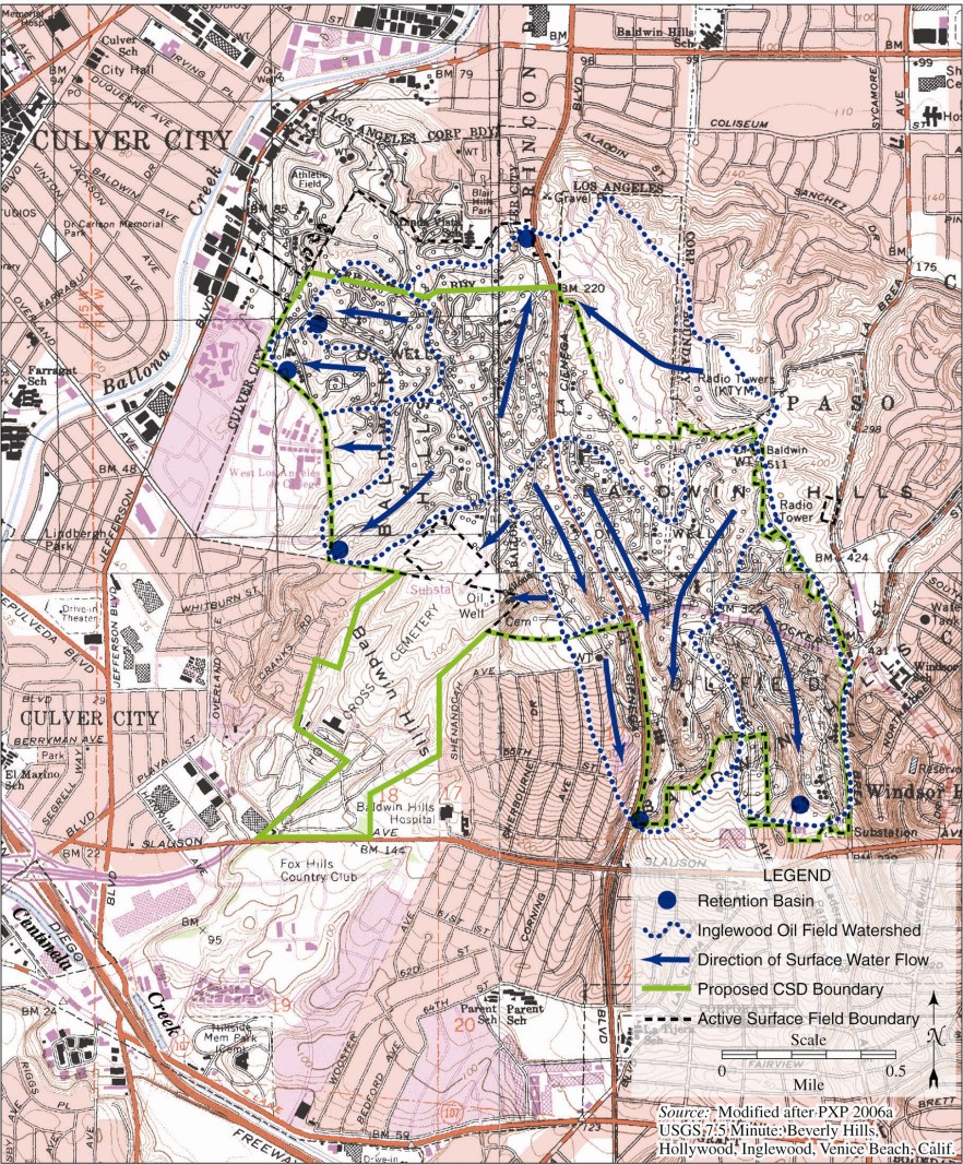
Surface water flows in the Inglewood Oil Field as mapped in the Baldwin Hills Community Standards District Environmental Impact Report.
Los Angeles County Flood Control District
The Baldwin Hills are located inside of the Los Angeles County Flood Control District, an organization that works with the department of Public Works, to provide “flood protection, water conservation, recreation and aesthetic enhancement within its boundaries”(https://dpw.lacounty.gov/lacfcd/).

image source: LA County Department of Public Works
The entirety of the Baldwin hills flood control area is divided into several zones that correspond to water runoff volumes, coefficients, and level of debris flows.
Ground Water
The Baldwin Hills Natural Area is located in the intersection three massive groundwater basins.
- The Santa Monica Basin
- The West Coast Basin
- The Central Basin Preserve Area

image source: LA County Department of Public Works
Within the natural area itself, the folding and faulting associated with tectonic activity has separated sediments that might hold groundwater from the surrounding groundwater basins. As a consequence, the Baldwin Hills generally do not have groundwater underneath them. For rainwater that falls onto the highlands, it first infiltrates through the hills’ permeable soils and continues to move downward into one of the three main water tables outside of the hills.
For more information:
Additional sources:
- Los Angeles County Deparment of Public Works
- Los Angeles Department of Water and Power
- Ballona Historical Ecology


